Glacier Peak
| Glacier Peak | |
|---|---|
| Dakobed Takobia | |
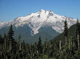 East slope of Glacier Peak with Cool (left), Chocolate (descending from summit), North Guardian and Dusty Glaciers (right) | |
| Highest point | |
| Elevation | 10,541 ft (3,213 m)[1][2] |
| Prominence | 7,498 ft (2,285 m)[2] |
| Listing |
|
| Coordinates | 48°06′43″N 121°06′51″W / 48.11194°N 121.11417°W[2][3] |
| Geography | |
  Glacier Peak Washington | |
| Location | Snohomish County, Washington, U.S. |
| Parent range | Cascade Range |
| Topo map | USGS Glacier Peak East |
| Geology | |
| Formed by | Subduction zone volcanism |
| Rock age | Pleistocene |
Mountain type | Stratovolcano[4] |
| Volcanic arc | Cascade Volcanic Arc[4] |
| Last eruption | 1700 CE[4] |
| Climbing | |
| First ascent | 1897 by Thomas Gerdine and party[5] |
| Easiest route | Rock/ice climb on Sitkum Glacier |
Glacier Peak or Dakobed (known in the Sauk-Suiattle dialect of the Lushootseed language as "Tda-ko-buh-ba" or "Takobia"[6]) is a stratovolcano in the U.S. state of Washington. The most isolated of the major Cascade volcanoes, it lies in Snohomish County about 70 miles (110 km) northeast of Seattle, deep within the Glacier Peak Wilderness of the Mount Baker–Snoqualmie National Forest. At 10,541 feet (3,213 m) it is the fourth-highest peak in Washington,[a][2] yet because it sits far back among other high summits it is much less conspicuous on the skyline than the taller Mount Rainier. It can be seen from Seattle to the west and from the higher eastern suburbs of Vancouver, British Columbia, to the north.
Glacier Peak is built mainly of dacite and rises only a few thousand feet above the high ridge on which it stands. It is one of the most active and explosive of Washington's volcanoes, and one of only two in the state—with Mount St. Helens—to have produced large explosive eruptions in the past 15,000 years.[7] About 13,100 years ago it produced some of the largest eruptions in the Cascade Range since the last ice age, sending lahars down its valleys as far as Puget Sound and spreading ash across the Pacific Northwest. It last erupted around 1700 CE, and its most recent large eruptions occurred about 1,100 years ago.
The United States Geological Survey (USGS) ranks Glacier Peak among the highest-threat volcanoes in the United States, with far-traveling lahars posing its greatest danger to communities in the Sauk, Stillaguamish, and Skagit river valleys.[8] Despite that threat it is the least monitored of Washington's volcanoes—watched as of 2024 by a single aging seismometer, with long-planned upgrades repeatedly delayed—and the USGS has never completed a detailed geologic map of it.[9][10] Eleven glaciers make it one of the most heavily glaciated of the Cascade volcanoes, but they have lost roughly a third of their area and may largely disappear within about 50 years.[11]
Long sacred to the Sauk-Suiattle people as Dakobed, the "Great Parent," the mountain was little understood by American settlers, who did not at first recognize it as a volcano. In the 1960s a proposed open-pit copper mine at nearby Miners Ridge became an early test of the Wilderness Act of 1964 and a landmark in American conservation history.[12] Today the peak lies within the 566,000-acre (229,000 ha) Glacier Peak Wilderness and is most often climbed by way of the Sitkum Glacier.
Geology
Glacier Peak is composed mainly of dacite and rises only about 1,600 to 3,200 feet (500 to 1,000 m) above the high, non-volcanic ridge on which it sits; its comparatively high summit is therefore largely a consequence of its elevated base.[7][13] The oldest lava flows erupted from the volcano now cap ridges north and east of the summit and have been radiometrically dated to between about 200,000 and 600,000 years old; the age of the cone itself is poorly known, because early deposits were eroded by glaciers and buried by younger volcanic rocks.[7] Remnants of prehistoric lava domes form the summit and its false summit, Disappointment Peak, a dacite dome about 250 metres (820 ft) south of the true summit.[14] The domes and dome fragments are aligned approximately north–south across the summit area, suggesting a persistent structural control on where lava emerged.[7]
Past pyroclastic flow deposits are visible in river valleys near the volcano, likely produced by lava-dome collapse, along with ridges east of the summit composed of ash-cloud deposits.[15] On its western flank, the volcano produced a lahar, or mudflow, that ran about 22 miles (35 km) into the White Chuck River valley around 14,000 years ago. Ten other pyroclastic flow deposits are visible, all about 10,000 years old, and a younger mudflow about 5,500 years old covers an area of 9.3 mi (15 km) in the same valley. Another lahar, of unidentified age, was rich in oxyhornblende dacite and continued 30 km (19 mi) into the Sauk River.[16]
There are also ash-cloud deposits on the eastern flank. In the Dusty Creek valley, which runs east from the mountain, there is a lahar at least 98 ft (30 m) thick, part of a 980-foot-thick (300 m) concentration of past deposits spanning the Dusty Creek and Chocolate Creek valleys that contains at least 2.4 cubic miles (10 km3) of lithic debris.[16] Tephra deposits are mostly constrained to the western flank, where at least nine eruptive units have been identified.[16]
About 5,900 ft (1,800 m) up the mountain are three additional cinder cones—one at the head of the White Chuck River, one at Dishpan Gap, and one near Indian Pass.[17] The volcano also hosts thermal features. Three hot springs once existed on its flanks—Gamma, Kennedy, and Sulphur[4]—but Kennedy Hot Springs, a popular destination reached by the White Chuck River Trail, was buried under several feet of silt, gravel, boulders, and logs in an October 2003 flood and is no longer accessible.[18]
Tectonic setting
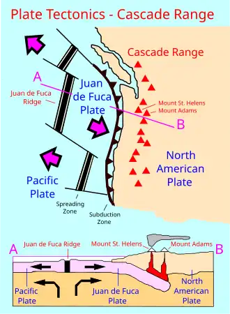
Glacier Peak is one of the five major stratovolcanoes in Washington. Like the rest of the Cascade Volcanic Arc, it was created by subduction of the oceanic Juan de Fuca Plate beneath the North American Plate,[19] with convergence between the two plates continuing at about 1.6 inches (4 cm) per year. The range has been volcanically active for roughly 36 million years.[20] A geochemical study of the northern Cascade Arc found that high-magnesium magmas near Glacier Peak mixed with crustally derived dacitic magma like that erupted by the volcano, evidence that both mantle melts and the continental crust contribute to its magmas.[21] About 15 kilometres (9.3 mi) west of the vent lies one of the higher concentrations of deep long-period earthquakes in the Cascades, thought to reflect the movement of magma or magmatic fluids at depth.[22]
Eruptive history
Of the five major volcanoes in Washington, only Glacier Peak and Mount St. Helens have produced large eruptions in the past 15,000 years. Because both generate viscous, dacitic magma that resists flowing through the vent, pressure builds until it is released explosively, ejecting tephra (volcanic ash and rock fragments).[15]
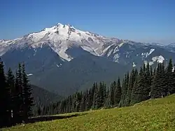
The volcano's largest known activity occurred about 13,100 years ago, when it generated a sequence of nine tephra eruptions within a period of less than a few hundred years. The largest of these ejected more than five times as much tephra as the 1980 eruption of Mount St. Helens and was among the largest eruptions in the Cascade Range since the end of the last ice age.[15] Two of these eruptions were Plinian, each erupting more than 1 cubic kilometre (0.24 cu mi) of magma and producing eruption columns more than 30 kilometres (19 mi) high, making them among the most powerful Cascade eruptions of the past 12,000 years.[23]
These eruptions sent pyroclastic flows that mixed with snow and ice to form lahars, which raced into nearby rivers and filled their valleys with deep deposits. The mudflows drained into the North Fork Stillaguamish River (at that time an outlet of the Sauk River) and the Skagit River, reaching Puget Sound; in Arlington, more than 60 miles (97 km) downstream, lahars deposited about 7 feet (2.1 m) of sediment. Most of the tephra reached high into the atmosphere and was carried hundreds of miles downwind: deposits were about 1 foot (0.30 m) thick near Chelan, roughly 0.3 inches (7.6 mm) near Missoula, Montana, and detectable as far southeast as Yellowstone.[15]
The most widespread of these tephra layers, the "G" and "B" beds, have been used by geologists and archaeologists across the Pacific Northwest as a regional time marker. A 2009 reanalysis revised their age to about 13,710 to 13,410 calibrated years before present and mapped the G bed across more than 550,000 square kilometres (210,000 mi2) of western North America.[24]
After a long pause, eruptions resumed by about 7,000 years ago and continued until before about 5,000 years ago, building and collapsing lava domes and producing pyroclastic flows. Sometime after 1,800 years ago, a large lahar—possibly triggered by a landslide high on the volcano—traveled at least 30 kilometres (19 mi) down the White Chuck River. The volcano's most recent large eruptive period occurred about 1,100 years ago, producing lahars and pyroclastic flows that swept valleys to the east and west.[25] A smaller, more recent eruption occurred around 1700 CE; known only approximately, from tephrochronology and Indigenous accounts, it is listed by the Global Volcanism Program as the volcano's last known eruption,[4] and USGS hazard studies place the most recent activity around the 18th century.[26] A 2026 study of tree rings identified pronounced cooling in the late 1690s that may be consistent with such an eruption, though its authors could not attribute the cooling to Glacier Peak with certainty.[27] Over the past 6,000 years the volcano has erupted at intervals of roughly 500 to 2,000 years.[25]
Hazards
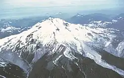
The annual probability of an eruption is estimated at about 1 in 1,000.[28] In the USGS's 2018 national volcanic threat assessment, Glacier Peak ranked as the 15th most dangerous volcano of 161 assessed in the United States and one of 18 designated "very high threat," alongside the Washington volcanoes Mount St. Helens, Mount Rainier, and Mount Baker.[8]
The principal hazard is from lahars. Effects would be most frequent in the White Chuck and upper Suiattle valleys and less frequent—but potentially more destructive, because of denser population and infrastructure—farther downstream in the Sauk and Skagit valleys.[29] Communities built partly on earlier lahar deposits and lying within the hazard corridor include Darrington, Rockport, Concrete, Sedro-Woolley, Burlington, and Mount Vernon; a major eruption's debris flows or sediment-laden floods could reach the lower Skagit and Stillaguamish valleys and potentially threaten Interstate 5.[29][9] The town of Darrington, about 25 miles (40 km) northwest of the volcano, sits on a level plain built largely by Glacier Peak lahar deposits and remains within the hazard zone.[29][15] Snohomish County requires builders in the hazard zone to sign disclosures acknowledging the land's exposure to potentially life-threatening mud, water, and debris flows, and local emergency managers have posted public-education signs near Darrington.[9]
When such flows reach populated areas they can bury structures and people, as in the 1985 Armero tragedy at Nevado del Ruiz, where about 23,000 people died.[15] A 2005 USGS study identified Glacier Peak among nine Cascade volcanoes that were "very-high-threat" yet inadequately monitored.[30]
Monitoring
Glacier Peak is the most sparsely monitored of Washington's volcanoes. As of 2024 it was watched by a single seismometer (station GPW), installed by the Pacific Northwest Seismic Network (PNSN) in 2001 about 2 kilometres (1.2 mi) from the summit; most of the signals it records are produced by glacier movement rather than volcanic activity, and the station cannot reliably locate the very small earthquakes that often precede an eruption.[31]
Efforts to expand monitoring have repeatedly stalled because the volcano lies within a federal wilderness area, where the helicopters and permanent structures involved are restricted. A 2018 USGS proposal to add new stations drew objections from conservation groups, including Wilderness Watch and the North Cascades Conservation Council, over helicopter use and installations in designated wilderness.[32] Separately, the National Volcano Early Warning and Monitoring System was authorized by the John D. Dingell, Jr. Conservation, Management, and Recreation Act, signed in March 2019, but was not fully funded.[32] In June 2022 the U.S. Forest Service granted a 30-year permit allowing four new monitoring stations and an upgrade of the existing one, which officials estimated would allow detection of roughly eight times as many earthquakes.[33] Installation was repeatedly delayed, however; in November 2024 the USGS reported that a helicopter-access problem and the discovery of unstable ground with no solid rock to anchor instruments had again postponed the work, leaving the volcano still monitored by its single aging seismometer.[10]
Climate
| Climate data for Glacier Peak Summit. 1991-2020 | |||||||||||||
|---|---|---|---|---|---|---|---|---|---|---|---|---|---|
| Month | Jan | Feb | Mar | Apr | May | Jun | Jul | Aug | Sep | Oct | Nov | Dec | Year |
| Mean daily maximum °F (°C) | 21.1 (−6.1) |
20.5 (−6.4) |
21.8 (−5.7) |
26.2 (−3.2) |
35.0 (1.7) |
41.3 (5.2) |
51.4 (10.8) |
51.9 (11.1) |
46.4 (8.0) |
35.8 (2.1) |
24.2 (−4.3) |
19.6 (−6.9) |
32.9 (0.5) |
| Daily mean °F (°C) | 16.0 (−8.9) |
14.0 (−10.0) |
14.1 (−9.9) |
17.2 (−8.2) |
25.1 (−3.8) |
30.8 (−0.7) |
39.4 (4.1) |
40.1 (4.5) |
35.3 (1.8) |
26.8 (−2.9) |
18.5 (−7.5) |
14.8 (−9.6) |
24.3 (−4.3) |
| Mean daily minimum °F (°C) | 10.8 (−11.8) |
7.5 (−13.6) |
6.4 (−14.2) |
8.3 (−13.2) |
15.2 (−9.3) |
20.2 (−6.6) |
27.4 (−2.6) |
28.2 (−2.1) |
24.2 (−4.3) |
17.8 (−7.9) |
12.9 (−10.6) |
9.9 (−12.3) |
15.7 (−9.1) |
| Average precipitation inches (mm) | 13.78 (350) |
10.65 (271) |
11.26 (286) |
6.59 (167) |
4.33 (110) |
3.33 (85) |
1.83 (46) |
2.27 (58) |
4.06 (103) |
11.31 (287) |
16.43 (417) |
16.18 (411) |
102.02 (2,591) |
| Source: PRISM Climate Group[34] | |||||||||||||
Glaciers
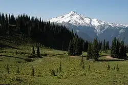
Eleven significant glaciers mantle Glacier Peak, making it the most heavily glaciated Cascade volcano after Mount Rainier and Mount Baker. The largest include the Chocolate, Cool, Dusty, Ermine, Kennedy, North Guardian, Ptarmigan, Scimitar, Sitkum, Suiattle, and Vista glaciers.[7] The mountaineer C. E. Rusk explored several of the glaciers around 1906, by which time they had begun retreating from their Little Ice Age maximum.[35]
The North Cascade Glacier Climate Project, led by glaciologist Mauri Pelto, has monitored these glaciers since the 1980s. The average retreat of Glacier Peak glaciers from the Little Ice Age to their 1958 positions was about 5,380 feet (1,640 m). Following a sharp rise in winter snowfall and cooler summers beginning in the 1940s, most of the glaciers advanced—by 50 to 1,575 feet (15 to 480 m)—and reached maximum positions around 1978 before resuming retreat by 1984.[35] The White Chuck Glacier shrank from about 3.1 square kilometres (1.2 mi2) in 1958 to roughly 0.9 square kilometres (0.35 mi2) by 2002, and the Milk Lake Glacier disappeared entirely in the 1990s.[35]
Glacier loss has accelerated in the 21st century. By 2025, according to Pelto, at least a third of the area of the mountain's glaciers had been lost, and below about 8,000 feet (2,400 m) the slopes had become bare rock or exposed ice; he projected that Glacier Peak could become essentially glacierless within about 50 years.[11]
Human history
Indigenous history
For the Sauk-Suiattle people, the mountain is Dakobed, commonly translated as "Great Parent" or mother mountain, and it holds deep spiritual significance.[6][11] The Sauk-Suiattle, canoe people of the Sauk, Suiattle, and neighboring rivers, regard Glacier Peak as a sacred place; a tribal representative has described it as central to their identity and tied to the salmon and mountain goats of the surrounding high country.[11]
Two sisters from the Sauk-Suiattle community, Edith Bedal and Jean Bedal Fish—daughters of the homesteader James Bedal and Susan Wawetkin, a daughter of Sauk chief John Wawetkin—recorded the oral history, legends, and place names of the Sauk and Suiattle people in their book Two Voices (2000), edited by the anthropologist Astrida R. Blukis Onat.[6] Jean Bedal Fish served as the tribe's chairman from 1979 to 1983 and worked for decades toward its federal recognition.[36]
Exploration and naming
In the 1850s, the ethnologist and naturalist George Gibbs recorded that Native Americans told him a peak north of Mount Rainier had once "smoked"—the first hint to settlers that it was a volcano.[15][9] Daniel Lindsley, a Northern Pacific Railroad employee scouting routes, is recorded as the first white observer of the mountain, in 1870.[7] Prospectors searching for gold reached the area in the 1870s through the 1890s, but the mountain did not appear on a published map under its current name until 1898.[15]
The first recorded ascent was made in 1897—though some sources give 1898—by a USGS surveying party led by the topographer Thomas Gerdine, accompanied by Sam Strom, A. H. DuBor, and Darcy Bard.[5]
Miners Ridge mining controversy
In December 1966, the Kennecott Copper Corporation announced plans to develop an open-pit copper mine at Miners Ridge, on claims beneath Plummer Mountain about a mile east of Image Lake, deep within the Glacier Peak Wilderness. Because the Wilderness Act of 1964 allowed valid pre-existing mining claims to be worked, the proposal became an early test of the act's mining provisions, and opponents memorably described the prospect as "an open pit visible from the moon."[12][37] Sierra Club executive director David Brower and Supreme Court Justice William O. Douglas—who led a protest hike toward the site—helped galvanize national opposition, and the North Cascades Conservation Council and Sierra Club ran advertisements against the mine.[12] The conflict was chronicled in John McPhee's 1971 book Encounters with the Archdruid, which recounts a debate between Brower and the mineral engineer Charles Park.[38]
No pit was ever excavated. Depressed copper prices combined with sustained public opposition led Kennecott to shelve the project and ultimately sell its claims in 1986, and the lands were later consolidated into the wilderness through a series of land exchanges.[12][39] The historian Adam M. Sowards examined the episode as a landmark in American conservation history in his 2020 book An Open Pit Visible from the Moon.[37]
Recreation
The mountain is the dominant feature of the Glacier Peak Wilderness, a remote backcountry area of about 566,000 acres (229,000 ha) spanning parts of Chelan, Snohomish, and Skagit counties and measuring roughly 35 miles (56 km) long by 20 miles (32 km) wide. The U.S. Forest Service first set the area aside administratively in 1960, and Congress designated it as statutory wilderness under the 1964 Wilderness Act; it is jointly managed by the Mount Baker–Snoqualmie National Forest and Okanogan–Wenatchee National Forest.[40][41][42] No roads reach the volcano; climbers approach on foot, typically from the west up the White Chuck or Suiattle river valleys, or from the east from the western tip of Lake Chelan or by way of the White and Chiwawa River valleys.[40]
The first recorded climb of the mountain was made in 1897 by Thomas Gerdine's USGS surveying party.[5] The standard route ascends the Sitkum Glacier and is rated Alpine Grade I or II;[5] climbers commonly approach via the North Fork Sauk River Trail and the Pacific Crest Trail to White Pass, then cross the Gerdine and Cool glaciers, passing the false summit Disappointment Peak. The easiest ski route, which follows the White Chuck River Trail and the Sitkum Glacier, has been rated blue to black diamond by the ski-mountaineering writer Amar Andalkar.[43]
The Pacific Crest Trail passes near Glacier Peak, and its crossing of the Suiattle River is a well-known feature. The original bridge over the Suiattle was destroyed by floods in late 2003; a replacement bridge was completed in 2011 about 2 miles (3.2 km) downstream at a more stable location, lengthening the trail's route by several miles.[44] The same 2003 floods devastated access on the west side of the volcano: the White Chuck River Trail was largely destroyed and the White Chuck River Road (Forest Road 23) was washed out and never fully restored, while the Suiattle River Road reopened in 2014 after extensive repairs.[18][40]
Cultural references
The Seattle-based composer Alan Hovhaness dedicated his Symphony No. 66, "Hymn to Glacier Peak", to the mountain, which was visible from his Seattle home; see Symphony No. 66 (Hovhaness).
The non-fiction book Encounters with the Archdruid by John McPhee, which portrays the environmental advocacy of David Brower, devotes the first of its three main sections to the conflict over mineral prospecting at Miners Ridge near Glacier Peak.
See also
- List of mountain peaks of North America
- List of mountain peaks of the United States
- List of mountain peaks of Washington (state)
- List of highest points in Washington by county
- List of mountain peaks of Washington (state)
- List of mountain peaks of the United States
- List of Ultras of the United States
- List of volcanoes in the United States
Notes
- ^ Glacier Peak is the fourth-highest independent peak in the state, after Mount Rainier, Mount Adams, and Mount Baker. Little Tahoma Peak (11,138 feet (3,395 m)), though higher than Glacier Peak, is a subsidiary summit of Mount Rainier rather than an independent peak.
References
- ^ "Glacier Peak". U.S. Geological Survey. Retrieved June 13, 2026.
- ^ a b c d "Glacier Peak, Washington". Peakbagger.com. Retrieved October 17, 2012.
- ^ "Glacier Peak". NGS Data Sheet. National Geodetic Survey, National Oceanic and Atmospheric Administration, United States Department of Commerce. Retrieved December 20, 2008.
- ^ a b c d e "Glacier Peak". Global Volcanism Program. Smithsonian Institution. Retrieved January 8, 2009.
- ^ a b c d Beckey, Fred (2003). Cascade Alpine Guide: Climbing and High Routes. Vol. Stevens Pass to Rainy Pass (3rd ed.). Seattle, Washington: Mountaineers Books. pp. 100–110. ISBN 0-89886-838-6. Retrieved February 21, 2017.
- ^ a b c Bedal Fish, Jean; Bedal, Edith (2000). Blukis Onat, Astrida R. (ed.). Two Voices – A History of the Sauk and Suiattle People, and Sauk Country Experiences. BOAS Inc.
- ^ a b c d e f "Geology and History of Glacier Peak". U.S. Geological Survey. Retrieved June 13, 2026.
- ^ a b Ewert, John W.; Diefenbach, Angela K.; Ramsey, David W. (2018). 2018 update to the U.S. Geological Survey national volcanic threat assessment (Report). Scientific Investigations Report 2018–5140. U.S. Geological Survey. doi:10.3133/sir20185140.
- ^ a b c d Mapes, Lynda V. (2018). "Washington's hidden Glacier Peak volcano is among the most dangerous". The Seattle Times. Retrieved June 13, 2026.
- ^ a b Aronson, Eliza (November 10, 2024). "2 years later, Glacier Peak seismometers delayed again". The Everett Herald. Retrieved June 13, 2026.
- ^ a b c d Ryan, John (September 19, 2025). "Glacierless Peak? The icy realms of Washington's North Cascades lose their cool". KUOW. Retrieved June 13, 2026.
- ^ a b c d Muhlstein, Julie (April 26, 2020). "An open-pit mine that wasn't: Ridge near Glacier Peak spared". The Everett Herald. Retrieved June 13, 2026.
- ^ Charles Arthur Wood; Juergen Kienle, eds. (1990). Volcanoes of North America - United States and Canada. Cambridge University Press. pp. 156–158. ISBN 978-0-521-43811-7.
- ^ "Summit of Glacier Peak". U.S. Geological Survey. Retrieved June 13, 2026.
- ^ a b c d e f g h Mastin, Larry G.; Waitt, Richard B. (2000). "Glacier Peak – History and Hazards of a Cascade Volcano". Fact Sheet 058-00. United States Geological Survey. Retrieved June 13, 2026.
- ^ a b c Begét, James E. (1982). Postglacial Volcanic Deposits at Glacier Peak, Washington, and Potential Hazards from Future Eruptions. Open-File Report 82-830. Denver, CO: U.S. Geological Survey. doi:10.3133/ofr82830. OCLC 8911553.
- ^ Tabor, R.W.; Crowther, D.F. (1994). "On Bathliths and Volcanoes – Intrusion and Eruption of Late Cenozoic Magmas in the Glacier Peak Area North Cascades, Washington". Geological Survey Professional Paper (604). Washington, D.C.: United States Geological Survey. hdl:2027/uc1.31822023316870. ISSN 0096-0446. OCLC 679317055. Retrieved May 5, 2023.
- ^ a b "White Chuck River Trail #643". U.S. Forest Service, Mount Baker–Snoqualmie National Forest. Retrieved June 13, 2026.
- ^ Brantley (1994). Volcanoes of the United States: USGS General Interest Publication. United States Geological Survey.
- ^ Swanson; et al. (1989). Cenozoic Volcanism in the Cascade Range and Columbia Plateau, Southern Washington and Northernmost Oregon: AGU Field Trip Guidebook T106. United States Geological Survey.
- ^ Sas, Maren; DeBari, Susan M.; Clynne, Michael A.; Rusk, Brian G. (2017). "Using mineral geochemistry to decipher slab, mantle, and crustal input in the generation of high-Mg andesites and basaltic andesites from the northern Cascade Arc". American Mineralogist. 102 (5): 948–965. doi:10.2138/am-2017-5756.
- ^ Nichols, M.L.; Malone, S.D.; Moran, S.C.; Thelen, W.A.; Vidale, J.E. (2011). "Deep long-period earthquakes beneath Washington and Oregon volcanoes". Journal of Volcanology and Geothermal Research. 200 (3–4): 116–128. doi:10.1016/j.jvolgeores.2010.12.005.
- ^ Gardner, James E.; Carey, Steven; Sigurdsson, Haraldur (1998). "Plinian eruptions at Glacier Peak and Newberry volcanoes, United States: Implications for volcanic hazards in the Cascade Range". Geological Society of America Bulletin. 110 (2): 173–187. Bibcode:1998GSAB..110..173G. doi:10.1130/0016-7606(1998)110<0173:PEAGPA>2.3.CO;2.
- ^ Kuehn, Stephen C.; Froese, Duane G.; Carrara, Paul E.; Foit, Franklin F.; Pearce, Nicholas J.G.; Rotheisler, Paul (2009). "Major- and trace-element characterization, expanded distribution, and a new chronology for the latest Pleistocene Glacier Peak tephras in western North America". Quaternary Research. 71 (2): 201–216. doi:10.1016/j.yqres.2008.11.003.
- ^ a b "Eruption History of Glacier Peak". U.S. Geological Survey. Retrieved June 13, 2026.
- ^ Gardner, C.A.; Scott, K.M.; Miller, C.D.; Myers, B.; Hildreth, W.; Pringle, P.T. (1995). Potential Volcanic Hazards from Future Activity of Glacier Peak, Washington (Report). Open-File Report 95-499. U.S. Geological Survey. doi:10.3133/ofr95499.
- ^ Paxton, O.; Harley, G. L.; Rader, E.; et al. (2026). "Late 17th-century cooling potentially linked to the most recent eruption of Glacier Peak (Washington, USA) recorded in tree rings". Natural Hazards. 122 (10). Article 435. doi:10.1007/s11069-026-08170-1.
- ^ "Hazards Summary for Glacier Peak". U.S. Geological Survey. Retrieved June 13, 2026.
- ^ a b c "Lahar Hazards at Glacier Peak". U.S. Geological Survey. Retrieved June 13, 2026.
- ^ Paulson, Tom (May 18, 2005). "Mount St. Helens still shrouded in secrets". Seattle Post-Intelligencer. Retrieved January 12, 2009.
- ^ "Earthquake Monitoring at Glacier Peak". U.S. Geological Survey. Retrieved June 13, 2026.
- ^ a b Bryan, Zachariah (January 17, 2022). "At deadly Glacier Peak, one last hurdle for new seismometers". The Everett Herald. Retrieved June 13, 2026.
- ^ Bryan, Zachariah (July 6, 2022). "Forest Service green-lights new seismometers at remote Glacier Peak". The Everett Herald. Retrieved June 13, 2026.
- ^ "PRISM Climate Group, Oregon State University". www.prism.oregonstate.edu. Retrieved January 12, 2022.
- ^ a b c Pelto, Mauri S. "Glacier Peak A Century of Change". North Cascade Glacier Climate Project. Retrieved June 13, 2026.
- ^ "Jean Bedal Fish". Snohomish County Women's Legacy Project. Retrieved June 13, 2026.
- ^ a b Sowards, Adam M. (2020). An Open Pit Visible from the Moon: The Wilderness Act and the Fight to Protect Miners Ridge and the Public Interest. Norman, Oklahoma: University of Oklahoma Press.
- ^ McPhee, John (1971). Encounters with the Archdruid. New York: Farrar, Straus and Giroux.
- ^ Sheets, Bill (May 6, 2010). "Swap adds Miner's Ridge to Glacier Peak Wilderness". The Everett Herald. Retrieved June 13, 2026.
- ^ a b c "Glacier Peak Wilderness". U.S. Forest Service, Okanogan–Wenatchee National Forest. Retrieved June 13, 2026.
- ^ "Glacier Peak Wilderness". Wilderness.net. University of Montana. Retrieved June 13, 2026.
- ^ Connelly, Joel (February 18, 2011). "North Cascades Conservation Council". HistoryLink. Retrieved June 13, 2026.
- ^ Andalkar, Amar (April 25, 2005). "Glacier Peak". skimountaineer.com. Retrieved January 28, 2009.
- ^ "Pacific Crest Trail soon back on track — 7 years later". The Seattle Times. 2010. Retrieved June 13, 2026.
External links

- Glacier Peak at the U.S. Geological Survey
- Glacier Peak on Ski Mountaineer.com
- "Glacier Peak". Peakware.com. Archived from the original on March 4, 2016.
- "Glacier Peak". SummitPost.org.
- University of Washington Libraries Digital Collections – The Mountaineers Collection
State of Washington | |||||||
|---|---|---|---|---|---|---|---|
Olympia (capital) | |||||||
| Topics | |||||||
| Society |
| ||||||
| Politics |
| ||||||
| Regions |
| ||||||
| Largest cities |
| ||||||
| Counties |
| ||||||
| |||||||